Showing posts with label Software. Show all posts

Monday, 3 April 2017

Trimble NavEdit Program @ HydroPRO Software


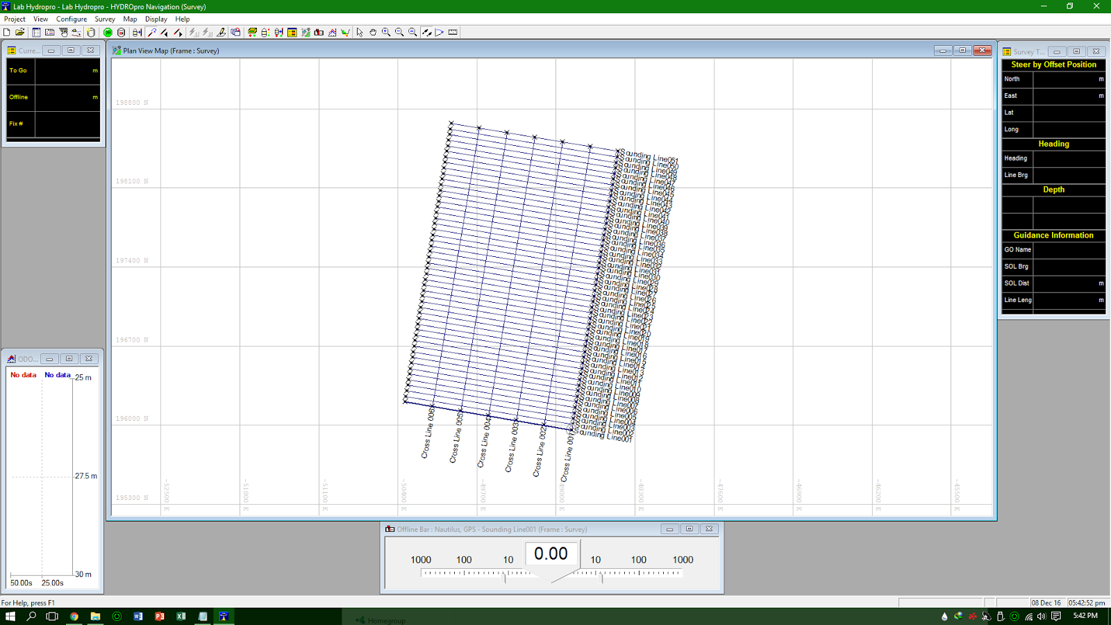
NavEdit is the graphical data visualization and cleaning tool that allows you to edit depth-related data such as recorded depth, heave, and tide. It is the link between the Navigation and Processing software components. This software developed too graphically and textually displays depth, heave, tide, and position information that has been acquired by the Navigation software. The NavEdit software creates an export file that can be imported directly into the Processing software

NavEdit is capable to provides hydrographic surveyors with the ability to view and edit depth and position data as well as the ability to edit individual depth and heave values. This program also able to plan View Map to provide graphically display the positional information and a Tide Editor tool that is used to create Tide files 

Once all the depth, heave, and position data has been checked and edited, the data is ready to be exported to the Processing software for final presentation and analysis.


Download Link :

NavEdit @ HydroPRO


Procedure and Manual Guide :

NavEdit Manual


Data Processing using Civil Design and Survey (CDS) Software


Civil Design and Survey (CDS) software is developed by Foresoft Pty Ltd Australia which consists of a suite of powerful design modules that interact seamlessly with the advanced digital terrain modelling and industrial strength CAD engines. It also gives you advanced design features and functionality to design roads, earthworks, sewer, stormwater and water networks. Together the modules combine to form an integrated design platform for civil engineering infrastructure as well as data gathering, drawing, and surface modelling.

CDS has been in use for over 15 years, that standard use as custom database. CDS Premium allows for future expansion as well as allowing to ‘add value’ by using common available tools such as Microsoft Access. CDS also incorporates a new display method in providing dynamic zoom and pan which is necessary to view larger data sets easily. It also make design of multiple road easier. Other than that, CAD also allow future add ons and enhancements.

CDS consist of tools that can design in 2 or 3 dimensional layer. In 2D arrangement are used in housing subdivision and industrial estates while roads and other facilities are designed in 3D. other than that, 3D design in CDS lets us combine individual point calculation at grade, string grading include vertical curves and templates with ‘ezi-sense’ that change ground conditions according to specific parameters. 

CDS also allow us to produce plats, subdivision layouts, annotated contour plans, profiles and section drawings directly to any Windows printing device. In addition, CDS also can insert borders, text, and symbols onto the plan within Ezicad before printing. We can also create a DWG file for further enhancement in any compatible CAD package.

Download link :

Civil Design and Survey.exe (Trial 60 days)


CDS Manual and Guide :

  1. Manual T-Com and CDS Software
  2. Data Transfer and CDS Step-by-Step Guide
  3. Data Processing in CDS


Sunday, 2 April 2017

Geodetic Datum Transformation System (GDTS) - Hydrographic Surveying (GLS 614)

   
Geodetic system is a coordinate system, and a set of reference points, used to locate places on the earth. Datums are used in geodesy, navigation, and surveying by cartographers and satellite navigation systems to translate positions indicated on maps to their real position on earth. Each starts with an ellipsoid and then defines latitude, longitude and altitude coordinates. The difference in co-ordinates between datums is commonly referred to as datum shift. Because the Earth is an imperfect ellipsoid, localised datums can give a more accurate representation of the area of coverage.


   In surveying and geodesy, a datum is a reference system or an approximation of the Earth's surface against which positional measurements are made for computing locations. Horizontal datums are used for describing a point on the Earth's surface, in latitude and longitude or another coordinate system. Vertical datums are used to measure elevations or underwater depths. Generally, especially in survey life the coordinate system need to change especially we conduct a survey in different place with different coordinate system to match the data and to gain the good result.


Software Used :
  1. GDTS 4.1 
  2. GPSCAS 1.02

Our Report and Procedure :


Saturday, 10 December 2016

HydroPRO Nav V2.2

The HYDROpro Navigation software operates on Windows operating systems. It provides an easy to understand graphical interface and flexible configuration that enables immediate gain with minimal training. The software supports multiple sensor inputs, ranging from heading sensors to tide gauges and echosounders. Combined with Trimble’s DGPS, RTK, or Total Stations it provides precise 3D positioning in real-time.

The HYDROpro Navigation software uses advanced time-stamping techniques for precise data synchronization. All data is stored in a single Microsoft Access database file to allow for more efficient file management activities.

The software’s flexible operation provides multiple ‘steerby’ capability, allowing guidance of multiple vessels and offsets to multiple guidance objects such as targets, lines, or routes. Guidance between mobile vessels is available. Any number of vessels can be monitored from a single location or across a network. Background files can be displayed graphically to show position in relation to guidance objects, coastal features, and so on. All of the displays, including the Remote Helmsman display, are available on seperate screens throughout a vessel.


Download Link :


Installation Guide : 

  1. Unzip the file
  2. Under HydroPRO folder run Autorun.exe
  3. Click Install HydroPRO and Utilities

Manual Instruction :


Procedure and Work Flow :


Tuesday, 6 December 2016

Dev C++ 5.11


Bloodshed Dev-C++ is a full-featured Integrated Development Environment (IDE) for the C/C++ programming language. It uses Mingw port of GCC (GNU Compiler Collection) as it's compiler. Dev-C++ can also be used in combination with Cygwin or any other GCC based compiler.


Features are :

- Support GCC-based compilers
- Integrated debugging (using GDB)
- Project Manager
- Customizable syntax highlighting editor
- Class Browser
- Code Completion
- Function listing
- Profiling support
- Quickly create Windows, console, static libraries and DLLs
- Support of templates for creating your own project types
- Makefile creation
- Edit and compile Resource files
- Tool Manager
- Print support
- Find and replace facilities
- CVS support


Download Link :


Monday, 5 December 2016

GNSS Solution 3.8


GNSS Solutions is a comprehensive office software with all of the tools required to successfully process GPS, GLONASS and SBAS survey data. Focusing on simplicity, GNSS Solutions guides you through planning, processing, quality control, reporting, data exporting and more.


Download :


Installation Guide :

1. Unzip the file

2. click Setup.exe

3. Click Install GNSS Solution 3.8


Video Tutorial